Usage of GNSS (Global Navigation Satellite Systems)
Introduction
GNSS stands for Global Navigation Satellite System and is the standard generic term describing any satellite constellation system that provides positioning, navigation, and timing (PNT) services on a global or regional basis. While USA’s GPS is the most prevalent GNSS, other nations have developed their own systems offering complimentary, independent PNT capability.
GNSS receiver onboard the PERCEPT Body Camera
The multi-GNSS receiver onboard the PERCEPT Body Camera gives it the advantage of being able to access multiple satellites (supports GPS/GLONASS/BDS), thereby increasing accuracy, redundancy, and availability of geolocation data at all times. Though satellite systems do not often fail, if one does fail, the receiver can pick up signals from the other systems. Also, if the line of sight is obstructed, having access to multiple satellites can prove to be very useful.
The differences between the different satellite systems supported on the PERCEPT Body Camera are detailed in the table below.
| System | GPS (Global Positioning System)  | GLONASS (Globalnaya Navigazionnaya Sputnikovaya Sistema)  | BDS (BeiDou Navigation Satellite System)  |
| Owner | United States of America (USA) | Russian Federation | People's Republic of China |
| Coverage | Global | Global | Global |
| First launch year | 1978 | 1982 | 2000 |
| Altitude | 20,180 km (12,540 mi) | 19,130 km (11,890 mi) | 21,150 km (13,140 mi) |
| Period | 11.97 h (11h:58 min) | 11.26 h (11h:16 min) | 12.63 h (12h:38 min) |
| Total satellite constellation (Operational satellites)* | 32 (31) | 27 (24) | 49 (44) |
| Accuracy | 7.8m | 4.5m – 7.4m | 3.6m (Public) / 0.1m (Encrypted) |
| Status* | Operational | Operational | Operational |
How does the GNSS receiver in the PERCEPT Body Camera get data from the satellites?
When it has a clear view of the sky, the GNSS receiver onboard the PERCEPT Body Camera constantly receives messages from multiple satellites. A message contains very precise timing information from the satellite to the Earth’s surface. Each satellite keeps sending messages with precise information on satellite orbit, as well as less precise information on the orbit of other satellites in the system. When the satellite signal is received, the GNSS receiver determines the distance from each satellite, and, with the use of geometry and trigonometry algorithms (“triangulation”), it calculates the exact position on or near the Earth’s surface. To determine the exact 2D position, the GNSS receiver needs a signal from at least 3 satellites. For the exact altitude above sea level, it requires a signal from at least 4 satellites.
How does the PERCEPT Body Camera use GNSS data?
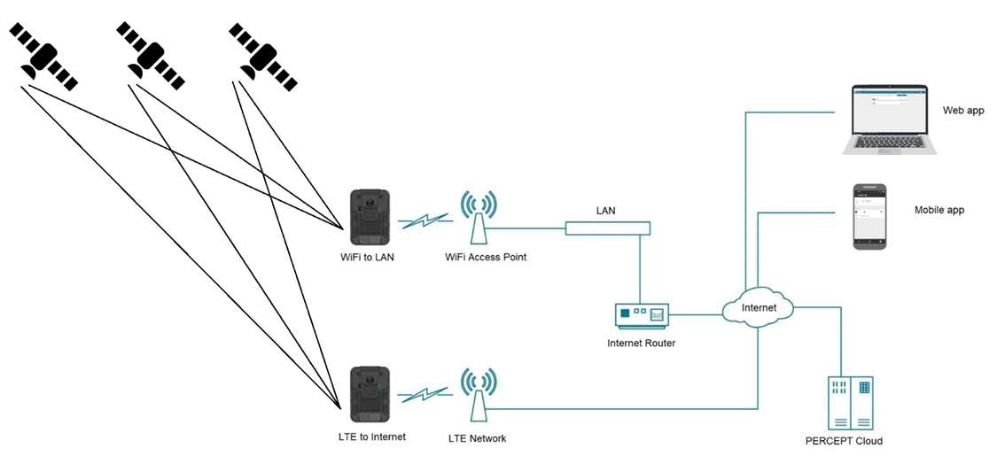
On the PERCEPT Body Camera, GNSS data is used for synchronizing the device’s date & time (this can also be done via the Cellular network if GNSS data is unavailable -> e.g., indoors), as well as for establishing the current geolocation. The information is then stored on the device’s internal memory and made available in real-time to end-users via the wireless networks (Wi-Fi or Cellular), through a dedicated metadata channel.
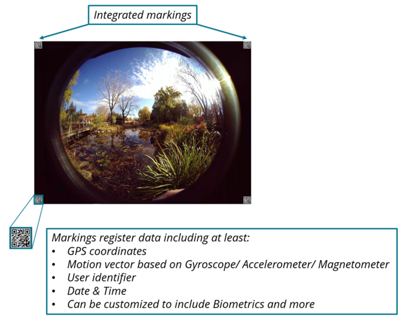
Geolocation information is also added to watermarks (QR codes) embedded into each captured video frame. During video playback, the client software that is processing video frames for display can decode the watermarks and provide the location of where each video frame was recorded. Additionally, users have the flexibility to stream geolocation data on its own, without video streaming (for example when available wireless bandwidth is restricted), when only location tracking is needed.
Conclusion
Geolocation data is critical for many body camera use-case scenarios. For mobile security and public safety personnel (private security, valuable goods transport, public transit security, port security, etc.), it allows for easier coordination between the different units in the field, as well as helping remote operators in a control center better assess a situation and dispatch the best resources (units closest to an incident) in an emergency situation. For enterprise and logistics companies, location awareness can be used to improve business processes (for example retracing and optimizing the path of delivery trucks & personnel).